Great North Road: Difference between revisions
| (4 intermediate revisions by 3 users not shown) | |||
| Line 5: | Line 5: | ||
=== Southern Section - Greenhill to Northern Realm === | === Southern Section - Greenhill to Northern Realm === | ||
Originally built by Seni to connect Greenhill to [[Northern Realm]], the road was originally a lightly used, unnamed path | Originally built by Seni to connect [[Greenhill]] to [[Northern Realm]], the road was originally a lightly used, unnamed path between these two towns. The construction of this path was elaborate, featuring wooden plank stairs and stone column lanterns for the travellers' convenience. At the southern and northern river crossings, elaborate bridges were also provided for, so as to not require boats. | ||
=== Central Section - Northern Realm to Wilatol === | === Central Section - Northern Realm to Wilatol === | ||
| Line 62: | Line 62: | ||
| | | | ||
|- | |- | ||
| | |Frog Street (nasin akesi) | ||
| | | | ||
|- | |- | ||
| Line 98: | Line 98: | ||
|- | |- | ||
| rowspan="2" |Upper Nostria | | rowspan="2" |Upper Nostria | ||
|Magnolia Inn | |[[Magnolia Inn]] | ||
| | | | ||
|- | |- | ||
| Line 112: | Line 112: | ||
|- | |- | ||
|Olwin i ilna (The Love Shack) | |Olwin i ilna (The Love Shack) | ||
|Gothic | |Gothic settlement monument | ||
|- | |- | ||
|St. Lawrence River | |St. Lawrence River | ||
Latest revision as of 09:03, 9 September 2024

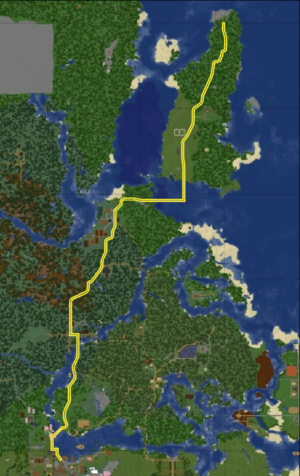
The Great North Road is a road connecting Greenhill to the northern tip of Horse Island. As the largest and longest road in Terra Nostra, it sees to the transportation needs of a large proportion of its residents.
History
Southern Section - Greenhill to Northern Realm
Originally built by Seni to connect Greenhill to Northern Realm, the road was originally a lightly used, unnamed path between these two towns. The construction of this path was elaborate, featuring wooden plank stairs and stone column lanterns for the travellers' convenience. At the southern and northern river crossings, elaborate bridges were also provided for, so as to not require boats.
Central Section - Northern Realm to Wilatol
Upon the founding of Wilatol, Kawa asked the Road Construction Authority to extend this road to the site of Wilatol, at the time a single house. In this request it was noted that the road should be wide enough for two people to ride horses past each other without stopping, equating to 4-5 blocks. This was provided for, using hill easements to smooth the road gradient and bridges to cross minor gulches.
Southern Section Upgrade
After the central section's construction was finished, the southern section was also expanded where possible to create a fully horse-navigable road. As a part of this upgrade, a short tunnel was created near the Manor House, bypassing the nearby lookout tower and allowing a smooth descent from the other side. At this time, discussions began about the naming of the Road, but a consensus had not been reached.
Horse Island Bridge

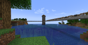
Upon the settling of Horse Island by Duke Malkus, a bridge was commissioned to cross the St. Lawrence River. The bridge is a large stone slab construction, featuring a central lighthouse which the bridge spans pass through, changing direction. The arches are as of yet incomplete, but the bridge is crossable.
Northern Section - Horse Island
The Horse Island section of Great North Road is slightly different from the rest of the Road, as it is narrower and yet to be fully upgraded. The route has a more rural feel, given the sparse development of Horse Island so far. The route serves the town area, the large statue, the Duke's Castle and meanders through the forests to the Manor at Horse Island's northern point.
Route
The route is highly varied, passing through oak and spruce forests, plains and taiga biomes. The route also features many hills and a few valleys, meaning that the elevation can also differ greatly.
Times (at regular walking speed) are as such:
| Waypoint | Elapsed Time | (Examples) Time of Day |
|---|---|---|
| Greenhill (Promenade) | 0:00 | 7:00 am |
| Northern Realm (Water Well) | 2:05 | 9:05 am |
| Wilatol (Kawa's House) | 1:50 (3:55) | 10:55 am |
| Horse Island Village (Malkus' House) | 1:50 (5:45) | 12:45 pm |
| Cobble Point Manor | 2:10 (7:55) | 2:55 pm |
Interchanges/Points of Interest
| Location | IC/POI | Notes |
|---|---|---|
| Greenhill, Greenhill | The Promenade (nasin telo) | |
| Frog Street (nasin akesi) | ||
| Northweald, Greenhill | Cherry Bridge | Seine crossing no.1 |
| Meow Island | Oak Street (towards Ballymena) | |
| Manor House | ||
| Hades Tunnel | Underground route bypassing previous ground-level route | |
| a Lookout Tower | ||
| Digragaida (𐌳𐌹𐌲𐍂𐌰𐌲𐌰𐌹𐌳𐌰) | Gothic boat in the Seine | |
| Birch Street (towards Ballymena, a Lookout Tower and Myousan Shrine) | ||
| Northern Realm Bridge (1) | Seine crossing no.2 | |
| Northern Realm | Northern Realm Bridge (2) | |
| The Well | Central point of Northern Realm | |
| Upper Nostria | Magnolia Inn | |
| Wilatol National Park | ||
| Wilatol | Kawa nai wi ilna (Kawa's House) | Central point of Wilatol |
| Inwo ilna (Storehouse) | ||
| Olwin i ilna (The Love Shack) | Gothic settlement monument | |
| St. Lawrence River | Horse Island Bridge | |
| Horse Island | Winged Woman Statue | |
| Malkus' House | Central point of Horse Island Village | |
| Soccer Fields | ||
| Horse Island Castle | ||
| Cobble Point Manor |
